Monday, December 9, 2013

Superior Hiking Trail - Critique 5


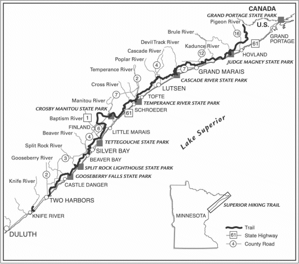
The Superior Hiking Trail is listed as one of the best hiking trails in the country.  It is over 275 miles long and extends from Duluth to the Canadian border.  This is the official map of the Superior Hiking Trail.  The first thing I notice is that it is not a color map, so this makes it tougher to see the figure-ground.  The darker gray of the land is visible though over the stark white of Lake Superior.  The legibility is good even with all the labels I am still able to read all of them.  Clarity is also surprisingly good with so many labels.  It appears that cities are in all caps and state parks are bolded.  Rivers are labeled smaller and are on the left side of the map.  I also like how they included an image of the location of this trail in Minnesota.  Balance is good in this map and the locations of labels are consistent.  Overall I think this is a well thought out map that shows mostly what you would need to know to hike the trail.  If they included locations of trail heads and campgrounds that would improve the map.

Middle Earth Map - Critique 4


Next time you venture into Middle Earth you may want to bring this map! Well... maybe you won't be going there anytime soon.  This map of Middle Earth doesn't really have much as far as figure-ground goes, but I still feel like it manages to look ok.  The legibility of the map is good, the larger the area is the larger the label is (even if you can't pronounce it).  The clarity of the map is good and there is no overlapping on labels. The balance of the map is a little off as most of the mapped area is on the right. Having the title in the bottom left helps balance it out, but is in a bit of an awkward place. The map was well thought out though and looks very nice. The color of the maps may seem a little dull but I think that's because they are going for the look of an old map or page of a book. 

Carson Park Map - Critique 3

This map of carson park was made by the Chippewa Valley Museum.  I really like this map because it is pretty detailed and this is a place I really like to visit (two blocks from my house).  The figure-ground in this map is very good.  It has a nice contrast from the blue water to the green land.  The Legibility of the map is ok, I would probably change the color of the numbered circles so that they don't blend in to the dark colored trees as much.  The clarity of the map is really good.  One spot it could be better is on the road that cross from Lake Street into Carson Park.  If it was a little wider using displacement I think it would look better.  The balance of the map is good, there isn't an uneven placement of things.  Lastly the Visual Hierarchy of the map.  The map maker should have included a scale.  I also really like how trees were included in the map.  This gives it a more realistic look and helps take up more space.

U.S. Lynchings 1882-1968- Critique 2


I want to start off by saying this is a pretty poor excuse for a map.  The figure-ground is ok, but that is about all for this map.  Legibility is pretty poor and the way she spaced her name and her sources is pretty weird.  The clarity of the map is also bad.  To make it easier to see she should have used circles instead of squares.  The image seems to be very pixely which doesn't help your map look very good. As far as the balance of the map it would look better if she kept her data source and name together.  Otherwise I think the balance is ok.  The visual hierarchy of the map is where she needs improvement.  This map was not well thought out.  The projection of the United States is pretty poor, and she left out Alaska.  In her note under the legend she says she doesn't have data for Hawaii or Alaska.  Why would she include only Hawaii (very distorted) on the map then? 

Wednesday, December 4, 2013

Lutsen Mountain Trail Map- Critique 1


This is a map of Lutsten Mountains Ski and Snowboard Resort.  I went here a couple of years ago with my friends family on vacation.  This map uses a landscape panorama map format, which Austrian painter Heinrich Berann made famous in the 1900s.  This map has pretty good figure-ground, using the natural colors based on a realistic image of what the mountains look like.  The legibility of the map is ok.  There are some smaller paragraphs of wording on the sides and in some of the legends, but I feel the cartographer did the best with the space he had available.  Also, the trail map is easier to read when you are holding a hard copy of it, not just looking off of a computer screen.  The Clarity of the map is consistent with the quality of the rest of the map.  There are good borders on the different images in the map and they do not overlap over anything important.  Balance is very good on this map.  The way it is layed out works well with what it is mapping.  There are images of each seperate mountain, the lodge area, and one big image encompassing all of them.  This map's visual hierarchy combines all of the other essentials of map design and overall I beleive this is a quality map based on how much needed to be mapped. 

Racial Populations in Denver, Colorado

Racial Populations in Denver, Colorado by DakotaDorn

Denver, Colorado is the sight of my newest map.  In this assignment I was to make four identical maps of downtown Denver and keep them at the same scale.  I then added data of different racial populations to each map.  Each map had to have a different color pattern, and the class breaks had to be the same for all of the maps.  This is the part that proved tough while working on this.  The reason is that Asian populations in Denver are very small so finding a class break that worked for all races was tough.  In the end I picked one that showed the other three well, and doesn't show much from the Asian population.  By not showing much though I am saying that there are not many that live there, so the data is still getting shown.  Another area of this map that was challenging was fitting all four maps and there legends in the document.  After changing fonts, adjusting font sizes, and scaling down the sizes of my maps I was able to make it work.

African American Population in the United States

African American Population in the United States by DakotaDorn

This is a proportional symbol map.  Unlike a graduated symbol map, this one shows exact values and not relative.  ArcGis makes adjusting the size of the minimum and maximum values very easy and even displays the size of each before you change the setting.  There are many adjustments that ArcGis allows you to make on these types of maps, but I am still not to the level where I know everything yet.  With some practice and maybe some light reading I might be able to figure out the vast unknown which is ArcGis.